RGB-3M

|
RGBT-3M is a large-scale aerial image dataset for wildfire detection in outdoor scenes. This dataset was captured by drones in multiple outdoor scenarios and consists of 11,220 registered RGB images and thermal infrared images. Each image has a spatial resolution of 640×480 pixels, and the label categories include smoke, flame, and people. When using this dataset in your work, please confirm and cite the relevant articlesThe detailed information of the dataset is described in our paper, which has been publicly released for research purposes.
Paper: https://www.mdpi.com/2072-4292/17/15/2593 Dataset: ①https://pan.quark.cn/s/9575da0a9dcc,code:ehjk ②https://pan.quark.cn/s/253ee29867c3,code:D3Dw(include raw data) Download: [Paper] [Dataset: Link/链接]
|
USTC_SmokeRS Dataset
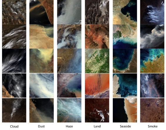
| The USTC_SmokeRS dataset is a new large-scale satellite imagery dataset for smoke scene detection. The dataset is collected based on Moderate Resolution Imaging Spectroradiometer (MODIS) data, consisting of 6225 RGB images from six classes including Cloud, Dust, Haze, Land, Seaside, and Smoke. The spatial resolution of each image is 1 km. These aerosol classes and land covers are selected as the result of the similar features with fire smoke and/or being the main classes in satellite imagery. The dataset can be used in fire smoke detection, and the recognition of these aerosol classes. The dataset details are elaborated in our paper, and it has been publicly released for research use. Download: [Paper] [Dataset: Link/链接] |
RGB-Thermal Wildfire dataset
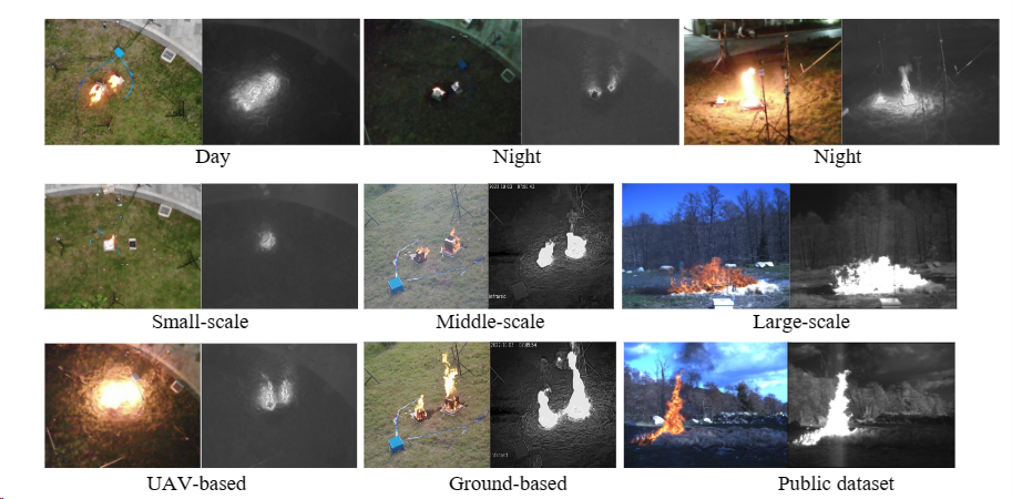
| The RGB-Thermal Wildfire dataset comprises 1367 paired images, featuring both RGB and Thermal modalities with corresponding pixel-level annotations. The dataset encompasses images of diverse resolutions, including 420×420 and 640×512. When utilizing this dataset in your work, kindly acknowledge and cite the associated article: Rui X, Li Z, Zhang X, et al. A RGB-Thermal based adaptive modality learning network for day–night wildfire identification[J]. International Journal of Applied Earth Observation and Geoinformation, 2023, 125: 103554. Download: [Paper] [Dataset: 校内下载链接;百度网盘(提取码:506n)] Other dataset in our paper can be seen in: Toulouse T, Rossi L, Campana A, et al. Computer vision for wildfire research: An evolving image dataset for processing and analysis[J]. Fire Safety Journal, 2017, 92: 188-194. |


